Day 2: Men and Boys
Appalachian Trail • 4 min read
Conditions: Low 70s, Partly Sunny
Distance: 15 miles
Woke up with my right shoulder stiff and my left knee sore. I popped an Aleve for a temporary fix. It wouldn't last. I'm carrying so much food I can't pack it right. One side of my backpack is heavier. So that shoulder suffers. It'll be a few days until I've eaten enough food for everything to fit right. Until then, I'll switch sides each day.
My knees aren't bad. It's just the weight and the elevation changes. I use the pain as an indicator of when to stop. Normally my knee starts to feel a little thick. When it does, I know I have another mile. Then I should rest.
Still a little uneasy on the trail. I keep looking for signs of bear. Watching for snakes. Nothing so far. I'm less uneasy than yesterday. I imagine in a few days I'll be one with nature.
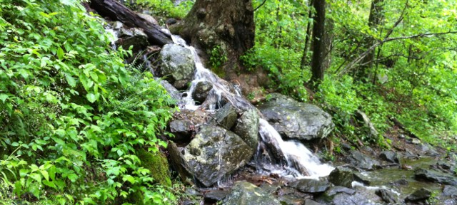
I powered through 6 miles in the morning. The goal is 16.8 miles for the day. While I planned for distance I didn't consider elevation changes. I crossed 3 mountains already. Still with Big Cedar and Blood Mountain ahead – the highest peak on the Appalachian Trail so far at 4,755ft. Good views though. The sun manages to come out when I reach the top of each. In addition, I passed an awesome waterfall. With all the rain, it flowed right across the trail.

I passed a few south-bounders on the trail in the morning. The first north-bounder I ran into was a college kid from Connecticut. He's a thru-hiker (Hiking Georgia to Maine). His goal is to complete the Appalachian Trail in 100 days. That's an average of 22 miles per day. I stopped to take a video while he kept going. I caught him a few miles up the trail filtering water. We discussed the “bear zone” ahead. Flyers were posted at each road crossing indicating a 6 mile stretch of the trail that had been designated “bear active”. To stay in this area required a bear canister – a crush proof capsule for your food. They were expensive and heavy. Most hikers didn't have them.
It was getting late in the day. We decided we'd get as far as we could. If necessary, we'd camp together in the “bear zone”. We pushed hard to a campsite about 1 mile from the edge of the “bear zone”. The elevation changes were slowing both of us. We were only a third of the way up Blood Mountain. We sat around the campsite for about 30 minutes. Unsure if we should push on or set up camp. We hadn't seen anyone else on the trail. Blood Mountain shelter was at the top. A little over a mile away and another 1000ft climb. We decided to go for it. We agreed to take breaks along the way and stay together. Just as yesterday, as the day winds down, so does morale. Exhaustion sets in. It's tough.
We stumbled into an empty Blood Mountain shelter around 7:30pm. A break in the clouds let the sun out and lifted our spirits. Since the shelter was empty, we decided to set up our tents inside. The shelter was an old stone cabin. Looked abandon for years. Like something out of Blair Witch Project. If nothing else, the tents could air dry from the rainy night before and would keep the critters out.
Blood Mountain had a rocky top. I used my last bit of energy to climb the highest boulder and enjoy the view. I felt like shit. I was hungry, tired, and dehydrated. I definitely pushed myself to the limit. My original goal was to make Neels Gap. Another 1.8 miles away. I would not have made it. Blood Mountain was far enough. I felt a lot better once I had dinner and a Propel mix. It provided the energy to spark up conversation with my fellow hiker. He didn't have a trail name. So I suggested “Machine”. He had been in front of me all day. Rarely stopping. I have no doubt he could have gone on to Neels Gap. But I was glad he stuck around.
I had passed several people during the day. A lot were questioning their commitment to the trail. Blood Mountain is the first milestone. It's nearly 30 miles from Springer Mountain. You cross several mountains before Blood Mountain. Combined with the “bear zone” it seems hikers were dropping out. With barely 1% of the trail complete, it had already separated the men from the boys. I was proud to make the first cut. Even if the downhill to Neels Gap would have to wait until morning.
A few lessons from the day:
- Know the topography of the trail. I only considered linear distance. Elevation changes play a huge factor.
- Drinking water alone will not keep you hydrated under such physical strain. You need electrolytes and minerals.
- You'll dig deep on the trail. And that won't always cut it. Sometimes you need a partner.
~ Bootstrapper – 0010
Find this interesting? Let's continue the conversation on Twitter.
